


Hex maps are fun, they add spice to a normal map while still providing valuable insights. A lot of online versions of hex maps involve data blending but in this article I'll show you the cheat sheet to using calculated fields to plot a U.S Hex Map.
Step 1:
Create three calculated fields.
First make a field called Columns: Inputting this calculation to the field. *If your state field name is different then change the [State] to whatever your field name is in the screenshot you will see Superstore has it as [State/Province]*
WHEN 'Alabama' THEN 7.5
WHEN 'Alaska' THEN 0.5
WHEN 'Arizona' THEN 3
WHEN 'Arkansas' THEN 6
WHEN 'California' THEN 2
WHEN 'Colorado' THEN 3.5
WHEN 'Connecticut' THEN 11
WHEN 'Delaware' THEN 9.5
WHEN 'District of Columbia' THEN 12
WHEN 'Florida' THEN 8.5
WHEN 'Georgia' THEN 8
WHEN 'Hawaii' THEN 0.5
WHEN 'Idaho' THEN 2
WHEN 'Illinois' THEN 6
WHEN 'Indiana' THEN 7
WHEN 'Iowa' THEN 5
WHEN 'Kansas' THEN 5
WHEN 'Kentucky' THEN 6.5
WHEN 'Louisiana' THEN 5.5
WHEN 'Maine' THEN 11.5
WHEN 'Maryland' THEN 8.5
WHEN 'Massachusetts' THEN 10.5
WHEN 'Michigan' THEN 7.5
WHEN 'Minnesota' THEN 4.5
WHEN 'Mississippi' THEN 6.5
WHEN 'Missouri' THEN 5.5
WHEN 'Montana' THEN 2.5
WHEN 'Nebraska' THEN 4.5
WHEN 'Nevada' THEN 2.5
WHEN 'New Hampshire' THEN 11
WHEN 'New Jersey' THEN 10
WHEN 'New Mexico' THEN 3.5
WHEN 'New York' THEN 9.5
WHEN 'North Carolina' THEN 9
WHEN 'North Dakota' THEN 3.5
WHEN 'Ohio' THEN 8
WHEN 'Oklahoma' THEN 4.5
WHEN 'Oregon' THEN 1.5
WHEN 'Pennsylvania' THEN 9
WHEN 'Rhode Island' THEN 11.5
WHEN 'South Carolina' THEN 8.5
WHEN 'South Dakota' THEN 4
WHEN 'Tennessee' THEN 7
WHEN 'Texas' THEN 4
WHEN 'Utah' THEN 4
WHEN 'Vermont' THEN 10
WHEN 'Virginia' THEN 8
WHEN 'Washington' THEN 1.5
WHEN 'West Virginia' THEN 7.5
WHEN 'Wisconsin' THEN 5.5
WHEN 'Wyoming' THEN 3
END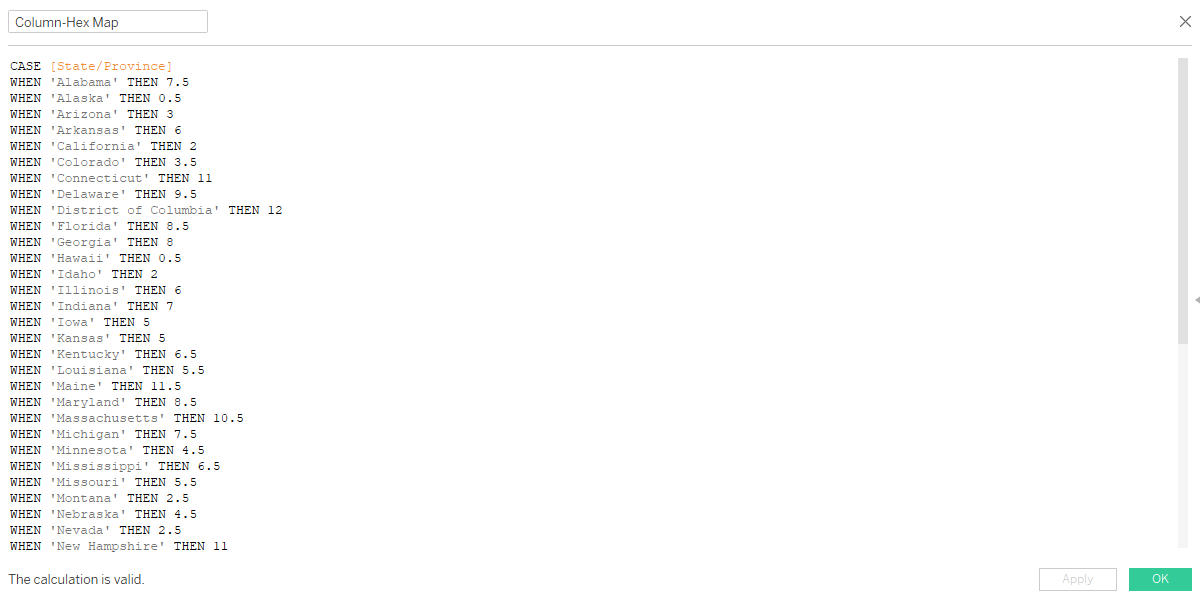
Now one for the Rows as well:
WHEN 'Alabama' THEN 6
WHEN 'Alaska' THEN 0
WHEN 'Arizona' THEN 5
WHEN 'Arkansas' THEN 5
WHEN 'California' THEN 5
WHEN 'Colorado' THEN 4
WHEN 'Connecticut' THEN 3
WHEN 'Delaware' THEN 4
WHEN 'District of Columbia' THEN 5
WHEN 'Florida' THEN 8
WHEN 'Georgia' THEN 7
WHEN 'Hawaii' THEN 8
WHEN 'Idaho' THEN 3
WHEN 'Illinois' THEN 3
WHEN 'Indiana' THEN 3
WHEN 'Iowa' THEN 3
WHEN 'Kansas' THEN 5
WHEN 'Kentucky' THEN 4
WHEN 'Louisiana' THEN 6
WHEN 'Maine' THEN 0
WHEN 'Maryland' THEN 4
WHEN 'Massachusetts' THEN 2
WHEN 'Michigan' THEN 2
WHEN 'Minnesota' THEN 2
WHEN 'Mississippi' THEN 6
WHEN 'Missouri' THEN 4
WHEN 'Montana' THEN 2
WHEN 'Nebraska' THEN 4
WHEN 'Nevada' THEN 4
WHEN 'New Hampshire' THEN 1
WHEN 'New Jersey' THEN 3
WHEN 'New Mexico' THEN 6
WHEN 'New York' THEN 2
WHEN 'North Carolina' THEN 5
WHEN 'North Dakota' THEN 2
WHEN 'Ohio' THEN 3
WHEN 'Oklahoma' THEN 6
WHEN 'Oregon' THEN 4
WHEN 'Pennsylvania' THEN 3
WHEN 'Rhode Island' THEN 2
WHEN 'South Carolina' THEN 6
WHEN 'South Dakota' THEN 3
WHEN 'Tennessee' THEN 5
WHEN 'Texas' THEN 7
WHEN 'Utah' THEN 5
WHEN 'Vermont' THEN 1
WHEN 'Virginia' THEN 5
WHEN 'Washington' THEN 2
WHEN 'West Virginia' THEN 4
WHEN 'Wisconsin' THEN 2
WHEN 'Wyoming' THEN 3
END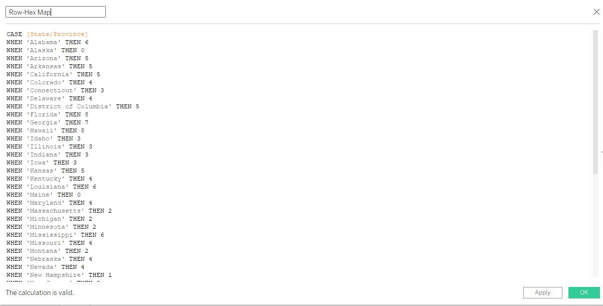
Lastly we will Abbreviate each states name for our labels
WHEN 'Alabama' THEN 'AL'
WHEN 'Alaska' THEN 'AK'
WHEN 'Arizona' THEN 'AZ'
WHEN 'Arkansas' THEN 'AR'
WHEN 'California' THEN 'CA'
WHEN 'Colorado' THEN 'CO'
WHEN 'Connecticut' THEN 'CT'
WHEN 'Delaware' THEN 'DE'
WHEN 'District of Columbia' THEN 'DC'
WHEN 'Florida' THEN 'FL'
WHEN 'Georgia' THEN 'GA'
WHEN 'Hawaii' THEN 'HI'
WHEN 'Idaho' THEN 'ID'
WHEN 'Illinois' THEN 'IL'
WHEN 'Indiana' THEN 'IN'
WHEN 'Iowa' THEN 'IA'
WHEN 'Kansas' THEN 'KS'
WHEN 'Kentucky' THEN 'KY'
WHEN 'Louisiana' THEN 'LA'
WHEN 'Maine' THEN 'ME'
WHEN 'Maryland' THEN 'MD'
WHEN 'Massachusetts' THEN 'MA'
WHEN 'Michigan' THEN 'MI'
WHEN 'Minnesota' THEN 'MN'
WHEN 'Mississippi' THEN 'MS'
WHEN 'Missouri' THEN 'MO'
WHEN 'Montana' THEN 'MT'
WHEN 'Nebraska' THEN 'NE'
WHEN 'Nevada' THEN 'NV'
WHEN 'New Hampshire' THEN 'NH'
WHEN 'New Jersey' THEN 'NJ'
WHEN 'New Mexico' THEN 'NM'
WHEN 'New York' THEN 'NY'
WHEN 'North Carolina' THEN 'NC'
WHEN 'North Dakota' THEN 'ND'
WHEN 'Ohio' THEN 'OH'
WHEN 'Oklahoma' THEN 'OK'
WHEN 'Oregon' THEN 'OR'
WHEN 'Pennsylvania' THEN 'PA'
WHEN 'Rhode Island' THEN 'RI'
WHEN 'South Carolina' THEN 'SC'
WHEN 'South Dakota' THEN 'SD'
WHEN 'Tennessee' THEN 'TN'
WHEN 'Texas' THEN 'TX'
WHEN 'Utah' THEN 'UT'
WHEN 'Vermont' THEN 'VT'
WHEN 'Virginia' THEN 'VA'
WHEN 'Washington' THEN 'WA'
WHEN 'West Virginia' THEN 'WV'
WHEN 'Wisconsin' THEN 'WI'
WHEN 'Wyoming' THEN 'WY'
END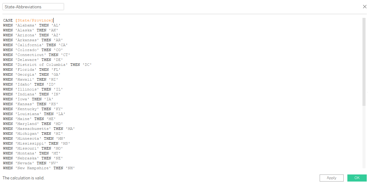
Step 2:
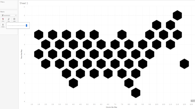
Lets set up our Axes.
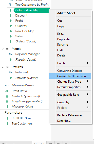
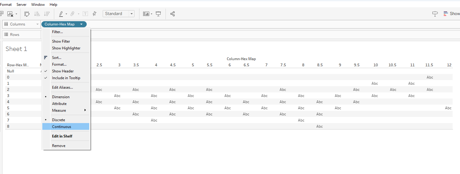
Make both of the Row/Column-Hex map fields Dimensions
Add Row-Hex Map to row and Column- Hex Map to columns and Change both to continuous:
Now reverse the Rows axis by right clicking and hit 'Edit Axis"
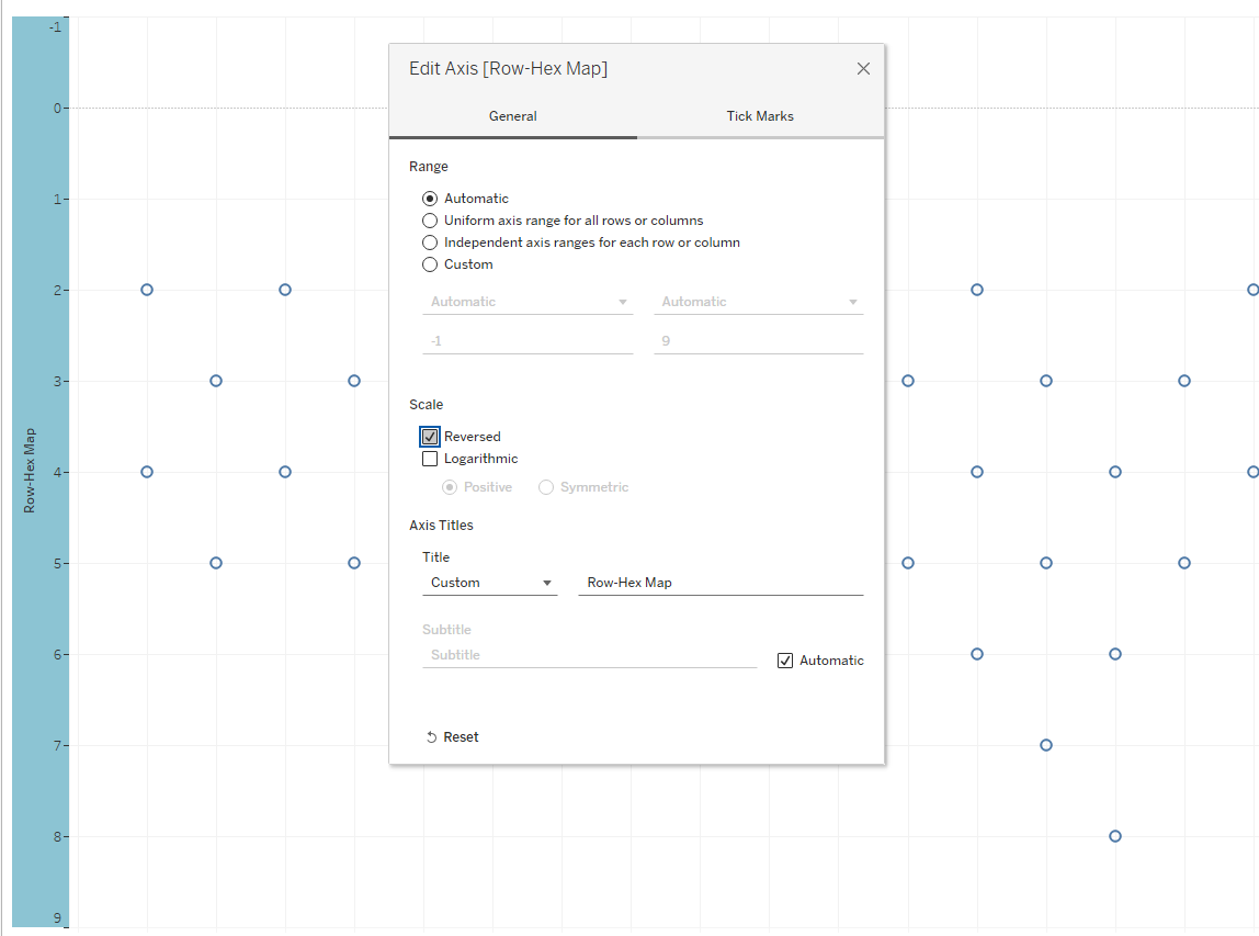
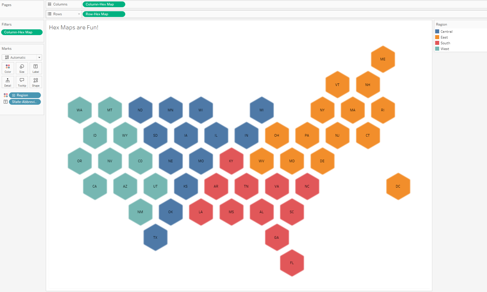
Now it should start looking like a map of the US!
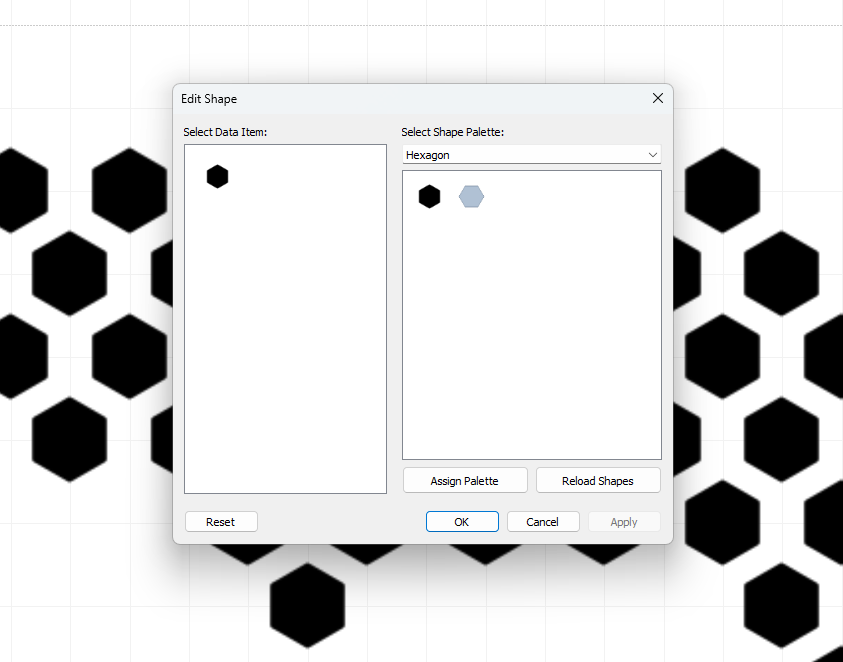
Next we will add the hex shape which can be downloaded here
Once downloaded a hexagon you like(preferably filled), navigate to your 'Tableau Repository" Folder and then into the 'shapes' Folder. You can make a new folder or place it into one of the existing folders.
Navigate to the Shapes tab on the Marks Card
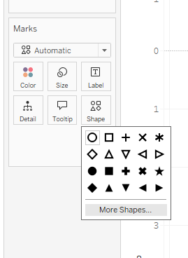
The shape will not automatically show up, you must click 'reload shapes'
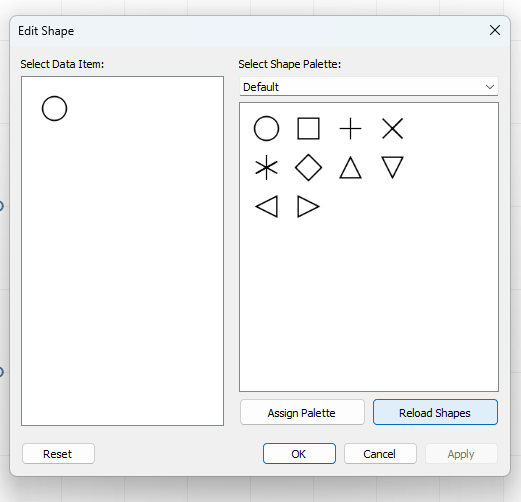
Then select the folder you put the hexagon in from the drop down menu and choose the hexagon(be careful for the exact shape, you want a hexagon with a pointy top and bottom)
Adjust the size until appropriate and it should start looking like a map!
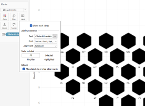
Lets add that State-Abbreviation field we made earlier to the label mark

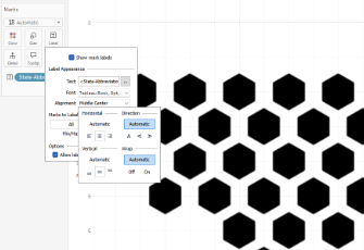
Now lets check 'Allow labels to overlap' and Center the abbreviations
And your Hex map is good to go! Hide the Axes, format the gridlines to make it more clean. But now you can add some color or use different formatting and have fun!!
Thank you for following along and credit to Matt Chamber's for the calculations.